

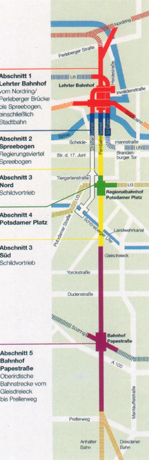
This is a map of the projects that comprise the new north-south connection through the heart of Berlin. Lehrter Station is in red, towards the top of the map. The east-west line across the city crosses at that point. The loop line crosses twice, at the top of the map and towards the bottom at Papestrasse. The landmark of Berlin, the Branderburg Gate, is along the blue section of the map, on the right side, and the new commercial center of Berlin, the Potsdamer Platz, is the green cross in the middle of the map.
Also of note is the landscape around the Lehrter Station. The Spree River runs just south of the station, and a major canal runs to the east.